Trends are hard to keep up with. Ever-changing, contradictory, and sometimes seemingly senseless, no one can stay perfectly up to date with what’s “in” and what’s “out.” Besides trends, we believe that free thought and personal style should lead the way when designing your space.
3D Modeling And Mapping Software Transforms Drone Data Into Digital Assets For Easy Analysis And Decision Making
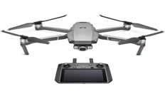
March 28, 2019 – DJI, the world’s leader in civilian drones and aerial imaging technology, today introduced DJI Terra, a new software tool that transforms drone data into digital 3D models and maps for easy analysis and decision making. DJI Terra enables businesses and organizations using DJI drone technology to capture, visualize and analyze aerial images for a wide variety of applications across the public safety, construction, infrastructure, agriculture and film industries.